It is said great things happen when men and mountains meet.  The Grampians or Gariwerd, to give it its Aboriginal name is another of these special places where things can be made to happen.  To fully benefit from hiking these mountains you’ll need a little intestinal fortitude, but when you arrive at a summit there’s the ultimate reward of the best views possible.  Fortunately, you don’t have to be a crazy pro climber to enjoy the majestic beauty of these mountains as the new track has you ascend the rocky escarpments in a safe and steady fashion. Moreover, there are ample walks that have a moderate to easy gradient if that is your preferred flavour. There are busy parts of the track, but the park is massive so be prepared to enjoy the beautiful silence at the top of a windswept summit or in the stunning gorges and valleys torn apart by millions of years of erosion. There’s also a ton of forest canopy to walk under and the odd waterfall to enjoy.

The completion of the Grampians Peaks Trail finally allows us to be able to fully immerse ourselves in the Grampians. The trail traverses the ancestral lands of the Djab Wurrung and Jadawadjali Peoples and travels the length of the Grampians from Mount Zero all the way to Mount Sturgeon and Dunkeld in the south.  Along the way you sight copious amounts of wildlife. kangaroos, wallabies, echidnas, reptiles and unheralded birdlife. The park is a sanctuary to many of Australia’s endangered species as the rough cliffs and valleys provide the perfect refuge.

The Grampians Peaks Trail – 7 Days

Group-guided

Rocky mountain ranges, 360-degree views from towering summits and heaps of wildlife. Mt Abrupt, Rosea, Sturgeon, William and Zero, Grand Canyon & the Pinnacle.

Group-guided 7 Days From $3495 Moderate to Challenging What's Included

The Grampians Peaks Trail – 7 Days

BACK
What's Included
  • Genuine all-inclusive pack free inspired walking holiday
  • A stunning handpicked selection of walks on the Grampians Peaks Trail
  • 2 professional and experienced guides
  • 6 nights comfortable accommodation in rooms with ensuites
  • Chef prepared cooked breakfasts, two-course dinners and comprehensive walkers lunches
  • All transport from Melbourne
  • National Park admission and the Auswalk guide pack including notes, maps, lunch bag and container

Grampians Peaks Trail Explorer 7 Day

Self-guided

Best parts of the Grampians Peaks Trail from Mount Zero to Dunkeld. Walk via Venus Baths, the Pinnacle, Mt Stapylton, Rosea, Zero and MacKenzie Falls.

Self-guided 7 Days From $2995 Moderate What's Included

Grampians Peaks Trail Explorer 7 Day

BACK
What's Included
  • 7 day pack free walking holiday
  • Walk the best of the Grampians Peaks Trail and Mackensie Falls
  • 6 nights’ accommodation with ensuites
  • Cooked breakfasts, chef-prepared dinners (4 nights only (5th-night included at Wickens if staying on weekend)) and substantial Walkers Lunches each day
  • All luggage transport and vehicle transfers (WITH OWN CAR THIS DIFFERS SLIGHTLY – SEE GENERAL INFO SECTION)
  • We shift you along the track from accommodation to accommodation to limit time in a vehicle, creating more time to relax and enjoy the region
  • National Park admission
  • Enjoy worry-free navigation with Auswalk’s comprehensive track notes, maps, map case, insulated lunch bag & info pack
  • 24/7 support from Auswalk’s representatives on the ground

Grampians Peaks Trail South 6 Day

Self-guided

Grampians Peaks Trail from Mount William to Dunkeld. Walk via  Mount Abrupt, Signal Point and Mount Sturgeon on the linear Southern GPT.

Self-guided 6 Days From $1995 Moderate What's Included

Grampians Peaks Trail South 6 Day

BACK
What's Included
  • 6-day pack free walking holiday
  • Walk the Southern Grampians Peaks trail from Mount William all the way to Dunkeld
  • Five nights’ accommodation with ensuites
  • Two a la carte dinners, cooked breakfast each morning and packed walkers lunches each day
  • Extra dinner at Wickens at Royal Mail on the weekend (surcharge for the weekend)
  • All luggage transport, vehicle transfers and National Park admission (WITH OWN CAR THIS DIFFERS SLIGHTLY – SEE GENERAL INFO SECTION)
  • We shift you along the track from accommodation to accommodation to limit time in a vehicle, creating more time to relax and enjoy the region
  • Enjoy worry-free navigation with Auswalk’s comprehensive track notes, maps, map case, insulated lunch bag & info pack
  • 24/7 support from Auswalk’s representatives on the ground

Grampians Peaks Trail Highlights 5 Days

Self-guided

Grampians Peaks Trail from Mount Zero to Dunkeld. Walk via Venus Baths, the Pinnacle, Mnt Rosea and Mnt Sturgeon.

Self-guided 5 Days From $1895 Moderate What's Included

Grampians Peaks Trail Highlights 5 Days

BACK
What's Included
  • 5 day pack free walking holiday
  • Walk 3 of the iconic walks on the Grampians Peaks trail
  • 4 nights’ accommodation with ensuites
  • Cooked breakfasts, 2 chef-prepared dinners (plus extra dinner on weekend at Royal Mail ( with surcharge)) and substantial Walkers Lunches each day
  • All luggage transport and vehicle transfers ((WITH OWN CAR THIS DIFFERS SLIGHTLY – SEE GENERAL INFO SECTION)
  • We shift you along the track from accommodation to accommodation to limit time in a vehicle, creating more time to relax and enjoy the region
  • National Park admission
  • Enjoy worry-free navigation with Auswalk’s comprehensive track notes, maps, map case, insulated lunch bag & info pack

OVERVIEW

Auswalk will provide you with all the first-world comforts that you’ll need to have a splendid walk and relaxing experience. You will stay in our favourite accommodations, taste the delicious fresh produce of the region. The idea is to traverse the trails with nothing more than a light day pack on your back, and we take care of the rest.

Auswalk offers two self-guided and one guided walk in the Grampians. We walk the Grampians Peaks Trail plus a few cameo walks that can be missed, particularly if you are in the region to walk. Effectively Auswalk provides a lot more walks as we can customize any of our walks to suit, adding more or taking away days to suit each walker’s specialised needs.


READ MORE

GRAMPIANS MAP

climate/weather

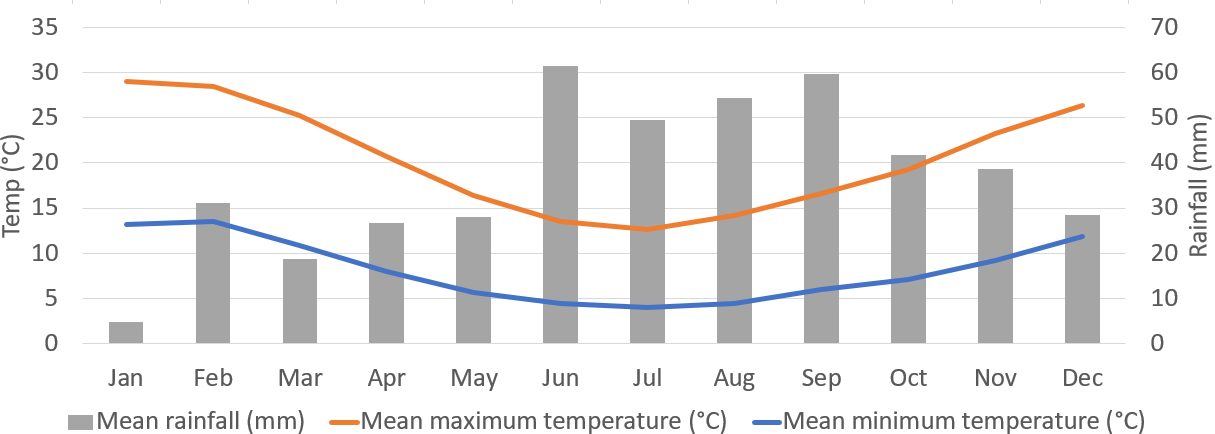
The climate on the Grampians Peaks Trail is warm and dry in summer and very cool in autumns. In winter it can get quite wet, but it rarely rains so much that it will ruin a whole day. If it rains heavily it tends to come down quickly and then clear up.

The Grampians Peaks Trail self-guided walking holidays are available year-round. However, October through to May is a more popular time to walk.  Please see our What To Bring section in FAQ’s for more information.

For more information please see the Bureau of Meteorology’s information concerning average temperatures and rainfall levels throughout the year.

Grampians Peaks Trail Weather average


walking essentials

As with any journey, it is essential to be prepared for your walking holiday. While we will be transporting your luggage from accommodation to accommodation, you will still be carrying a lightweight day pack with you. Here is what we suggest that you carry with you each day:

  • Walking notes, a map, and a map case
  • Picnic lunch packed in an insulated container (when supplied)
  • Quality waterproof jacket with a hood
  • Warm jumper or jacket
  • Sunhat
  • Comfortable walking shoes
  • Sunscreen (at least 15+)
  • 1 to 2 litres of water
  • First aid kit
  • Toilet paper
  • Some money
  • Mobile phone (please note that reception is not available in all walk areas)
  • Personal insect repellent, band-aids, and a small container of salt mixed with rice grains
  • Personal necessities (example: required medication)

Now that we have the essentials packed, it is time to think of those additional items that may be worth packing along with you. These may include and are not limited to:

  • Waterproof over-trousers
  • Warm hat
  • Sunglasses
  • Camera (with an extra battery or sim cards)
  • Binoculars
  • Notebook and pen
  • Matches
  • Small torch
  • Walking stick
  • Thermos (for hot drinks)
  • Additional snacks

PEAKS TRAIL SECTIONS

NORTH 1: MOUNT ZERO TO BARIGAR

The walk starts from the trailhead at the very northern end of the park. Hike through a natural amphitheatre over rocky escarpments to the summit of Mount Stapylton. The reward from completing the first summit are the expansive views over the Wimmera Plains. We like to start the walk from Mount Zero the most northerly summit in the Grampians national park, this is a short detour of about 2 hours.

Walk: 12.9km /  Moderate / 4-5 hrs


NORTH 2: BARIGAR TO GAR

The walk begins with a gentle amble along a low ridge with views out to Mount Difficult and Briggs Bluff. There’s a fairly difficult climb via some cascading waterfalls to Gar to get to just below Mount Difficult. Expect to see plenty of wildlife.

Walk: 11.3km / Easy to Moderate / 4-5 hrs


NORTH 3: GAR TO WERDUG

Today is a bit of up and down as we traverse the eastern escarpment of Mount Difficult. The views out over the Pyrenees and the Black ranges are outstanding. The views also extend out over the Wartook Basin. The walk finishes at Werdug near Lake Wartook.

Walk: 14km /  Moderate / 4.5 -5.5 hrs


NORTH 4: WERDUG TO HALLS GAP

This is another day of up and down but it is well worth it as the views are a constant antidote to the rigours of walking the Grampians Peaks Trail. You will make your way via rocky outcrops and witness magnificent views over Lake Wartook. The views don’t end there but continue as you make your way to Chatauqua Lookout. The walk ends today in the tourist town of Halls Gap. A reward of a cold beer or a glass of wine might be in order.

Walk: 13km / Easy to Moderate / 4-5 hrs


CENTRE 1: HALLS GAP TO BUGIGA

Today’s walk is the busiest but really the only place you are going to see other people. It is also one of the best walks in the park. The walk makes its way through the delightful Venus Baths and over Elephant Hide and then through the Grand Canyon to the Pinnacle and the amazing lookout. The views over Halls Gap and Lake Bellfield are some of the best on the walk.  The walk ends at Bugiga.

Walk: 8.6km / Moderate / 3.5-4.5 hrs


CENTRE 2: BUGIGA TO BARRI YALUG

There are some really nice small detours today, one to Sundial lookout and another to Silverband falls, both well worth a visit. The walk winds its way down to Rosea car park and then a real climb up to the summit of Mount Rosea. It’s a walk that has been touted as the number one walk in the park, at least by Auswalk guides. You will come to rest at Barri Yalug having walked via Borough Huts.

Walk: 14.2km /  Moderate / 5 -6 hrs


CENTRE 3: BARRI YALUG TO DUWUL

Walking in the shadow of Mount William, over cascades of rocky terraces and the Seven Dials shaped by millions of years of erosion.  You continue on to Redman Bluff which allows for 360-degree views over the surrounding plains and back over the mountains. The track then descends down to Duwul and the end of the day’s walk.

Walk: 12km / Moderate to hard / 5-6 hrs


CENTRE 4: DUWUL TO DURD DURD

Today’s walk ascends the highest mountain in the Range Mount William. It is characterised by you guessed it more continuous outstanding views. The walk then descends steeply to Boundary Gap and Durd Durd via the Major Mitchell Plateau.

Walk: 15.6km / Moderate / 5-6 hrs


CENTRE 5: DURD DURD TO YARRUM

Today’s walk begins with a descent to Jimmy Creek Road and back up to the ridgeline once again. By now you will be used to the up and down nature of the Grampians Peaks Trail. This section of the track is probably the most remote part of the park. It comes with the reward of excellent sunset views over the western section of the ranges.

Walk: 12.5km / Moderate / 5-6 hrs


SOUTH 1: YARRUM TO WANNON

From Yarrum we descend to Hidden Valley and cross the road and back up along an escarpment with great views over the Sierra range. Today’s walk ends at Wannon a nice grassy valley with lots of kangaroos.

Walk: 11.9km / Moderate / 5-6 hrs


SOUTH 2: WANNON TO DJARDJI-DJAWARA

You start today’s walk with a flat section out from Wannon via Wannon Fan. The track climbs up the other side of Grampians Road and winds its way upwards. Once you get to the highest point today the track then makes its’ way along the Sierra Range eventually making its way to Djardji-djaware.

Walk: 15.4km / Moderate / 5-6 hrs


SOUTH 3: DJARDJI-DJAWARA TO MUD-DADJUG

This is said to be a hard walk due to the severe gradient of the track. As the name Mount Abrupt indicates this Mountain looks as though it has crashed out of the earth and has rocketed up into the sky. There’s some good old fashion climbing to be done today, none of it difficult other than a lot of it is up. It can be arduous if you are not prepared, but given your preparation from the first eleven days of walking you should be ready. You end today at Mud-Dadjug perched up high on the plateau just below Mount Abrupt.

Walk: 10.4km / Moderate to hard / 4.5-6.5hrs


SOUTH 4: MUD-DADJUG TO DUNKELD

Today you make your way down from Mount Abrupt via the Picanninny a small knoll then up to Mount Sturgeon.  From here you have your last expensive views of the walk over the plains and the small hamlet of Dunkeld. If you walk this track from end to end it might be worth taking a small detour up to Mount Zero as mentioned on day 1. So that you can say you walked from peak to peak. The first peak at the northern end is officially Mount Staplyton, so don’t be concerned if you didn’t walk Mount Zero, you’ve accomplished the Grampians Peak Trail.

Walk: 12.1km / Moderate to hard / 5-6 hrs


Overview

OVERVIEW

Auswalk will provide you with all the first-world comforts that you’ll need to have a splendid walk and relaxing experience. You will stay in our favourite accommodations, taste the delicious fresh produce of the region. The idea is to traverse the trails with nothing more than a light day pack on your back, and we take care of the rest.

Auswalk offers two self-guided and one guided walk in the Grampians. We walk the Grampians Peaks Trail plus a few cameo walks that can be missed, particularly if you are in the region to walk. Effectively Auswalk provides a lot more walks as we can customize any of our walks to suit, adding more or taking away days to suit each walker’s specialised needs.


READ MORE
GRAMPIANS MAP

GRAMPIANS MAP

climate/weather

climate/weather

The climate on the Grampians Peaks Trail is warm and dry in summer and very cool in autumns. In winter it can get quite wet, but it rarely rains so much that it will ruin a whole day. If it rains heavily it tends to come down quickly and then clear up.

The Grampians Peaks Trail self-guided walking holidays are available year-round. However, October through to May is a more popular time to walk.  Please see our What To Bring section in FAQ’s for more information.

For more information please see the Bureau of Meteorology’s information concerning average temperatures and rainfall levels throughout the year.

Grampians Peaks Trail Weather average


walking essentials

walking essentials

As with any journey, it is essential to be prepared for your walking holiday. While we will be transporting your luggage from accommodation to accommodation, you will still be carrying a lightweight day pack with you. Here is what we suggest that you carry with you each day:

  • Walking notes, a map, and a map case
  • Picnic lunch packed in an insulated container (when supplied)
  • Quality waterproof jacket with a hood
  • Warm jumper or jacket
  • Sunhat
  • Comfortable walking shoes
  • Sunscreen (at least 15+)
  • 1 to 2 litres of water
  • First aid kit
  • Toilet paper
  • Some money
  • Mobile phone (please note that reception is not available in all walk areas)
  • Personal insect repellent, band-aids, and a small container of salt mixed with rice grains
  • Personal necessities (example: required medication)

Now that we have the essentials packed, it is time to think of those additional items that may be worth packing along with you. These may include and are not limited to:

  • Waterproof over-trousers
  • Warm hat
  • Sunglasses
  • Camera (with an extra battery or sim cards)
  • Binoculars
  • Notebook and pen
  • Matches
  • Small torch
  • Walking stick
  • Thermos (for hot drinks)
  • Additional snacks
PEAKS TRAIL SECTIONS

PEAKS TRAIL SECTIONS

NORTH 1: MOUNT ZERO TO BARIGAR

The walk starts from the trailhead at the very northern end of the park. Hike through a natural amphitheatre over rocky escarpments to the summit of Mount Stapylton. The reward from completing the first summit are the expansive views over the Wimmera Plains. We like to start the walk from Mount Zero the most northerly summit in the Grampians national park, this is a short detour of about 2 hours.

Walk: 12.9km /  Moderate / 4-5 hrs


NORTH 2: BARIGAR TO GAR

The walk begins with a gentle amble along a low ridge with views out to Mount Difficult and Briggs Bluff. There’s a fairly difficult climb via some cascading waterfalls to Gar to get to just below Mount Difficult. Expect to see plenty of wildlife.

Walk: 11.3km / Easy to Moderate / 4-5 hrs


NORTH 3: GAR TO WERDUG

Today is a bit of up and down as we traverse the eastern escarpment of Mount Difficult. The views out over the Pyrenees and the Black ranges are outstanding. The views also extend out over the Wartook Basin. The walk finishes at Werdug near Lake Wartook.

Walk: 14km /  Moderate / 4.5 -5.5 hrs


NORTH 4: WERDUG TO HALLS GAP

This is another day of up and down but it is well worth it as the views are a constant antidote to the rigours of walking the Grampians Peaks Trail. You will make your way via rocky outcrops and witness magnificent views over Lake Wartook. The views don’t end there but continue as you make your way to Chatauqua Lookout. The walk ends today in the tourist town of Halls Gap. A reward of a cold beer or a glass of wine might be in order.

Walk: 13km / Easy to Moderate / 4-5 hrs


CENTRE 1: HALLS GAP TO BUGIGA

Today’s walk is the busiest but really the only place you are going to see other people. It is also one of the best walks in the park. The walk makes its way through the delightful Venus Baths and over Elephant Hide and then through the Grand Canyon to the Pinnacle and the amazing lookout. The views over Halls Gap and Lake Bellfield are some of the best on the walk.  The walk ends at Bugiga.

Walk: 8.6km / Moderate / 3.5-4.5 hrs


CENTRE 2: BUGIGA TO BARRI YALUG

There are some really nice small detours today, one to Sundial lookout and another to Silverband falls, both well worth a visit. The walk winds its way down to Rosea car park and then a real climb up to the summit of Mount Rosea. It’s a walk that has been touted as the number one walk in the park, at least by Auswalk guides. You will come to rest at Barri Yalug having walked via Borough Huts.

Walk: 14.2km /  Moderate / 5 -6 hrs


CENTRE 3: BARRI YALUG TO DUWUL

Walking in the shadow of Mount William, over cascades of rocky terraces and the Seven Dials shaped by millions of years of erosion.  You continue on to Redman Bluff which allows for 360-degree views over the surrounding plains and back over the mountains. The track then descends down to Duwul and the end of the day’s walk.

Walk: 12km / Moderate to hard / 5-6 hrs


CENTRE 4: DUWUL TO DURD DURD

Today’s walk ascends the highest mountain in the Range Mount William. It is characterised by you guessed it more continuous outstanding views. The walk then descends steeply to Boundary Gap and Durd Durd via the Major Mitchell Plateau.

Walk: 15.6km / Moderate / 5-6 hrs


CENTRE 5: DURD DURD TO YARRUM

Today’s walk begins with a descent to Jimmy Creek Road and back up to the ridgeline once again. By now you will be used to the up and down nature of the Grampians Peaks Trail. This section of the track is probably the most remote part of the park. It comes with the reward of excellent sunset views over the western section of the ranges.

Walk: 12.5km / Moderate / 5-6 hrs


SOUTH 1: YARRUM TO WANNON

From Yarrum we descend to Hidden Valley and cross the road and back up along an escarpment with great views over the Sierra range. Today’s walk ends at Wannon a nice grassy valley with lots of kangaroos.

Walk: 11.9km / Moderate / 5-6 hrs


SOUTH 2: WANNON TO DJARDJI-DJAWARA

You start today’s walk with a flat section out from Wannon via Wannon Fan. The track climbs up the other side of Grampians Road and winds its way upwards. Once you get to the highest point today the track then makes its’ way along the Sierra Range eventually making its way to Djardji-djaware.

Walk: 15.4km / Moderate / 5-6 hrs


SOUTH 3: DJARDJI-DJAWARA TO MUD-DADJUG

This is said to be a hard walk due to the severe gradient of the track. As the name Mount Abrupt indicates this Mountain looks as though it has crashed out of the earth and has rocketed up into the sky. There’s some good old fashion climbing to be done today, none of it difficult other than a lot of it is up. It can be arduous if you are not prepared, but given your preparation from the first eleven days of walking you should be ready. You end today at Mud-Dadjug perched up high on the plateau just below Mount Abrupt.

Walk: 10.4km / Moderate to hard / 4.5-6.5hrs


SOUTH 4: MUD-DADJUG TO DUNKELD

Today you make your way down from Mount Abrupt via the Picanninny a small knoll then up to Mount Sturgeon.  From here you have your last expensive views of the walk over the plains and the small hamlet of Dunkeld. If you walk this track from end to end it might be worth taking a small detour up to Mount Zero as mentioned on day 1. So that you can say you walked from peak to peak. The first peak at the northern end is officially Mount Staplyton, so don’t be concerned if you didn’t walk Mount Zero, you’ve accomplished the Grampians Peak Trail.

Walk: 12.1km / Moderate to hard / 5-6 hrs


blog

March 18, 2024

HIKING THE HIMALAYAS 35 YEARS ON

Read More
March 4, 2024

What’s the right Camino de Santiago route for me?

Read More
February 16, 2024

Larapinta Loonies – A poem by Auswalker Michael Gibbs about walking the Larapinta Trail

Read More
January 12, 2024

Nakasendo Way Trail – by Sam Ludbey

Read More
April 19, 2023

H is for Hiking

Read More
March 27, 2023

Kumano Kodo Pilgrimage Trail – Overview of the Routes

Read More
March 20, 2023

The Kumano Kodo Trail – an Ancient Japanese Pilgrimage

Read More
March 15, 2023

The Three Capes Track – an Ultimate Guide to Hiking

Read More
February 13, 2023

Why Hiking is a No Brainer for Life Planning

Read More
January 31, 2023

Larapinta Trail – What is the Best Time of Year to Walk?

Read More

ENQUIRE NOW

If you’re looking for further information on any of our walking holidays please fill out the enquiry form and we’ll be in touch.

Get in touch